Active alerts
No active NWS alerts for Hawaiʻi statewide. This page refreshes every 5 minutes. No alert is a fact about this moment, not a forecast. Stay with NWS Honolulu and your county emergency agency.
Tsunami (PTWC)
- Information: NEAR THE EAST COAST OF KAMCHATKA RUSSIA (M7.0(Mwp))
HI-EMA
- Governor Green Issues Third Proclamation Relating to the May 22, 2026 Kona Earthquake
- Governor Green Issues Tenth Proclamation Relating to March and April 2026 Weather Events
- Governor Green Issues Third Proclamation Relating to the 2026 Wildfire Season
- NEWS RELEASE: Monthly Siren and Emergency Alert System Test for October 2026
- Governor Green Issues Third Proclamation Relating to September 2026 Tropical Cyclones
Right now
- Honolulu: 77°F, 74% humidity, wind NE 8 mph
- Līhuʻe: 77°F, 71% humidity, wind NE 17 mph
- Molokaʻi: 75°F, 83% humidity, wind NE 10 mph
- Lānaʻi: 73°F, 78% humidity, wind NE 13 mph
- Kahului: 75°F, 89% humidity, wind NE 10 mph
- Hilo: 71°F, 90% humidity, wind SW 7 mph
- Kona: 77°F, 74% humidity, wind E 6 mph
Tides
Nāwiliwili
- High 1.8 ft at Fri, Oct 16, 7:54 AM HST
- Low 0.4 ft at Fri, Oct 16, 11:34 PM HST
- High 1.7 ft at Sat, Oct 17, 9:08 AM HST
Honolulu Harbor
- High 1.8 ft at Fri, Oct 16, 8:13 AM HST
- Low 0.5 ft at Fri, Oct 16, 4:49 PM HST
- High 0.6 ft at Fri, Oct 16, 7:54 PM HST
- Low 0.5 ft at Sat, Oct 17, 12:17 AM HST
Kaunakakai
- High 2.0 ft at Fri, Oct 16, 8:03 AM HST
- Low 0.5 ft at Fri, Oct 16, 11:59 PM HST
- High 1.9 ft at Sat, Oct 17, 9:23 AM HST
- Low 0.5 ft at Sat, Oct 17, 6:44 PM HST
Kaumālapaʻu
- High 2.0 ft at Fri, Oct 16, 8:15 AM HST
- Low 0.5 ft at Fri, Oct 16, 4:52 PM HST
- High 0.8 ft at Fri, Oct 16, 7:56 PM HST
- Low 0.5 ft at Sat, Oct 17, 12:20 AM HST
Kahului Harbor
- Low 0.4 ft at Fri, Oct 16, 10:25 PM HST
- High 1.9 ft at Sat, Oct 17, 8:32 AM HST
- Low 0.6 ft at Sat, Oct 17, 11:06 PM HST
Hilo
- High 2.2 ft at Fri, Oct 16, 7:09 AM HST
- Low 0.5 ft at Fri, Oct 16, 11:40 PM HST
- High 2.1 ft at Sat, Oct 17, 8:35 AM HST
Stream gauges
Tropical cyclones
- Central North Pacific Tropical Weather Outlook
- There are no tropical cyclones at this time.
- No current storm in CPHC Central North Pacific Wallet 1
- No current storm in CPHC Central North Pacific Wallet 2
Forecast discussion
A high pressure system far northwest of the Hawaiian Islands will slowly drift from west to east over the next few days. This passing system will increase easterly trade winds into the moderate to breezy range lasting into the middle of next week. Brief pulses of enhanced showers are forecast with three passing easterly waves during this time period. Increasing shower trends will favor the windward and mauka areas in the overnight to early morning hours starting tonight and lingering into Tuesday morning. The strongest of these three waves will pass through the islands from late Sunday through late Monday.
Full discussion
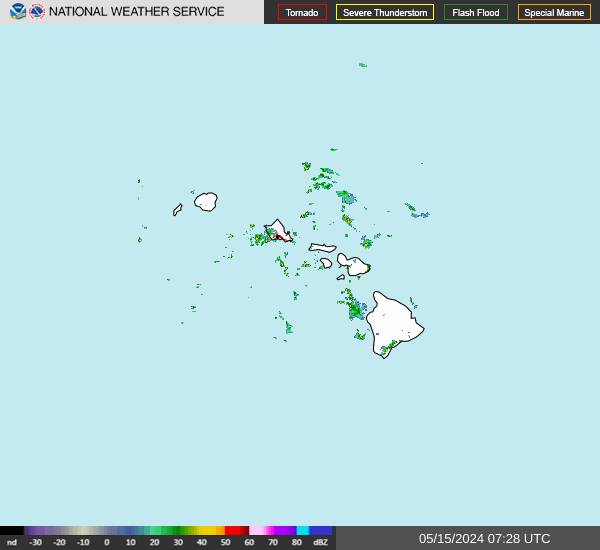
Radar shows scattered windward and mauka showers across the state this morning. A large surface high continues to strengthen to our north. Aloft, a weak upper level low to our east will become a trough that stretches from southern CA all the way out to us. The trough will be weak, and apart from a slight increase in instability, we won't see much from it. Several impulses of increased moisture will move toward and over the state, especially the eastern end, over the coming week. The first will move through this afternoon and evening, and reach all islands. The second should move over the area late Sunday through late Monday, boosting showers mainly across the eastern end of the state. Finally, another area may reach us next Thursday, but at this time range confidence is low. Models currently indicate the focus of this one would be on the eastern end. Trade winds will remain moderate to breezy through the coming week, with the a slight increase possible Tuesday evening. A slight weakening may develop next Thursday, but as mentioned in the previous paragraph, at seven days out, confidence in that level of detail is low. Finally, guidence indicates that the upper level trough extending from southern CA over to us may join with energy moving in from the northwest and strengthen toward the middle of next week. It is unclear at this time whether it will develop into a closed low or a stronger trough. Either way, it may draw tropical moisture northward toward the state and present a heavy rain threat. Details should become clearer in a few days.
Radar
Open the current Hawaiʻi radar still